Horseback Riding California’s Central Sierras
Great Horse Trails along The Texas Flat - California Meadow Loop in the Central Sierras, part of the Equitrekking 50 State Trail Riding Project.
by Sherry Antill & Ann Bates of Central Sierra Nevada Horse Trails
The central Sierra’s of California offer horseback riders a plethora of trails for riders of all levels of experience. Less experienced riders can gain confidence riding the trails that Bass Lake has to offer, while riders accustomed to more challenging terrain will love the trails from Fish Camp and the surrounding areas just south of the entrance into Yosemite National Park.
.jpg)
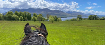
California Meadow.
One of the favorite trails for us locals is the “Texas Flat - California Meadow Loop”. The entire loop, without stopping for lunch, is 5-6 hours long. There are several creek crossings, lush meadows, a trek through the Nelder Grove of Giant Sequoias and the return through California Meadow which was the site of Lumber Mill #2 (1879 - 1884). Lumber was processed at the mill, plied for drying, put into a flume at the end of the meadow and sent to Madera, California.
Starting at the dirt turnout staging area on Sky Ranch Road (Rd. 632), your first destination will be Texas Flat, a primitive campground that includes several group horse campsites. Some of the sights you will see on your way will be Soquel Meadow, a grove of very young Sequoias and an old, uninhabited 2-story cabin. Passing through Texas Flat Campground, your next destination will be Kelty Meadow, also a primitive campground that includes equestrian camping as well. One of the highlights at Kelty Meadow is the view of Fresno Dome. The meadow is one of our favorite rest and water stops, and the horses don’t mind snacking on the lush grass as well.
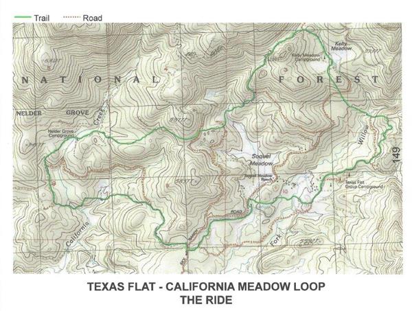
Texas Flat - California Meadow Loop map for horse trails.
Leaving Kelty Meadow, you are now heading toward the back side of Soquel Meadow. Many of the trails are abandoned railroad grades used during the extensive logging which took place between the late 1800s and 1920s. This particular section of the trail is fairly rocky, so consider bringing along hoof boots if horses are not shod. The trail switches from logging roads, single track trails and short sections of dirt forestry roads on your way to Nelder Grove.
The trail heading into Nelder Grove is one of the most scenic of the loop. In spring, the Dogwoods are in bloom. Late spring and early summer has massive blooms of wild azaleas and tall blue lupine. In fall, the dogwood leaves turn to lovely pastels with vibrant red seed pods where there were once creamy white flowers the size of saucers! The abundant black oaks also are a show of color with their golden orange leaves against dark trunks and branches.
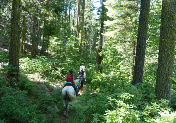
Trail heading into Nelder Grove.
When entering the Nelder Grove behind the “Bull Buck” tree, be sure to take the short trail on the left to the viewing spot where you can see this magnificent tree in all it’s glory. The “Bull Buck” tree is estimated to be 2700 years old, 250 feet tall and 100 feet around the base, and is one of the most symmetrical sequoia’s we have ever seen! Nelder Grove campground is also a primitive campground and another lovely lunch and water stop.
As you exit Nelder Grove, you will be turning to the right. A short distance and on the left is the trail which heads to California Meadow. This entire area is the summer home of free range cattle and you are likely to see them at the various meadows. Just before entering the meadow you will cross a creek with black plastic webbing used for erosion control. As this crossing can be boggy early in the season, staying to the right will keep you on firmer ground.
Heading away from California Meadow, you make a fairly steep climb up a single track trail ending at a dirt forestry road. Turn right and make your way back to Sky Ranch Road and the staging area.
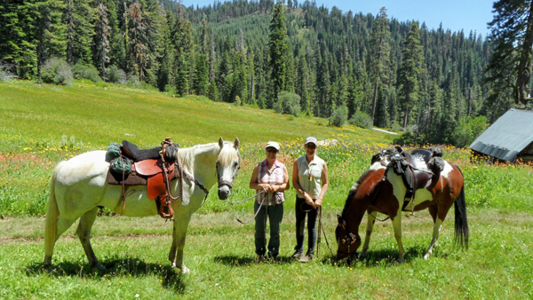
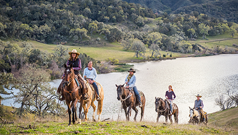
Sherry Antill and Ann Bates, the authors, riding in the Central Sierras.
About the Authors: In North Fork, CA, a small town nestled in the foothills of the Sierras and just south of Yosemite National Park, two women have located, ridden and mapped over 40 equestrian trails. Sherry Antill and Ann Bates were not satisfied with the dozen or so trails known to the riders in the area, so in 2007 they set out on a quest to locate trails and paths, mainly within a 50-mile radius, that could be day rides for local horse owners. From picking the brains of the old timer’s and cattle ranchers who would summer their cattle at the higher elevations, to following caravans of trucks hauling horse trailers, Sherry and Ann were able to add 20 unique trails to their expanding folder. Over the next couple of years they added more than 20 additional day rides without any repeats! The trails range in mileage from 6 to 20 miles round trip. This resulted in the printing of two trail books, “Central Sierra Nevada Horse Trails”, volumes one and two. Learn more at CSNhorsetrails.com.